Sawtooth Mountain
I've been wanting to get out to Sawtooth Mountain for a long time. It's a great little mountain, but tends to slip down the priority list in the summer when there are grander peaks to climb. With this year's very mild fall (so far), I had a good opportunity this month to go and cross this one off my to-do list.
I initially tried to go on Sunday the 14th. The forecast was for a bit of wind--20 MPH at the summit--but it didn't look too bad. But as soon as I got past Hills Creek Lake and was headed east on Forest Service Road 21 (Rigdon Road), I was surprised at the increasing and sustained ferocity of the wind. The road was covered in small branches and pine cones and the gusts were quite remarkable. I initially thought about canceling, but I remained optimistic and pressed on. Then I had to stop to clear a downed tree off the road. Fortunately the tree broke into manageable pieces when it fell, so I was able to clear a gap wide enough to get my car through.
About two miles before I reached the trailhead at Timpanogas Lake, I decided this whole endeavor was probably unwise. It was 31 degrees and the wind was howling at about 30 MPH with stronger gusts. There was a very good chance that a tree would come down and block my exit back to Highway 58 and in this area there's no cell signal to call for assistance. And I knew if I went out to hike in this that it would be a bitterly cold and miserable experience, so I cursed the bad forecast and turned around to head home.
I went back a week later on the 21st, and I couldn't ask for a better day. It was cool and still and sunny--a perfect Oregon fall day.
Coming in to Timpanogas Lake from Rigdon Road, you have to endure 7 or 8 miles on a wide, gravely dirt road (Road 2154) that is heavily washboarded on every incline and curve. It'll really rattle the fillings out of your teeth.
I made a pit stop at the Timpanogas campground, which is really just about 100 yards from the trailhead. Just so you know, the Sawtooth Mountain/Indigo Lake trailhead has the benefit of a toilet at the Timpanogas campgrounds, so it's always nice to be able to comfortably take care of business before hiking, if you know what I'm saying.
I had a leisurely start from the house, and after the 90-mile drive I finally hit the trail at around 10:30. I took the southwest trail instead of the more direct Indigo Lake trail so I could see more of the area. It was fairly steep and heavily wooded, so although the woods were very pretty, there wasn't much to see.
I was dismayed to see that pretty much everything was allowed on this trail system. People, horses, bikes, and even motorcycles. Now I know dirt-biking is a heck of a lot of fun, but I wish pristine wilderness areas such as this could be free of motorized vehicles. Plus I think that motorcycles on a trail that's heavily used by hikers is just a bad idea. And motorcycles and horses on a rugged, narrow trail? That's definitely a bad combo. At any rate, I was enjoying the hike and I didn't expect to really see any dirt bikers out here.
A bit after taking a left at the June Lake trail junction, I got to the Indigo Lake trail three-way junction about a mile into the hike. I took the middle fork--the Sawtooth Mountain trail. You can also get to the summit via the Indigo Lake trail but I was going for a counter-clockwise loop just because it looked like the best way to go on paper. You get most of the climbing out of the way before the summit trail so it's not a long climb to the summit like it would be from the Indigo Lake trail.
After another mile I was crossing the high ridge running down from southeast to northwest, and the trail got very rugged and quite steep in spots. Certainly not something I'd want to try on either a mountain bike or a motorcycle. It looked like a trail that didn't get much use, and sure enough I didn't see anyone on it all the way up to Sawtooth. I had the forest all to myself.
Gaining the saddle about a mile to the west of the Sawtooth summit, the trail turned east to approach Sawtooth's south side. The hiking here was scenic, easy and pleasant, but there were not yet any views of Sawtooth so it was difficult to gauge just where I should be looking for the turnoff to head up to the summit.
Just about when I thought I'd gone too far east and passed it, I came across the unmarked summit trail and from there it was a relatively short hike with a bit of scrambling around gendarmes and up some rocks to get to the summit. Partway there I came around a rock formation and an older gentleman, the first person I'd seen all day, was sitting nearby eating some lunch. He and I both jumped a bit. He exclaimed, "You scared the shit out of me!", to which I replied, "Well you scared the shit out of me, too!". We both had a little chuckle. He was heading down so after a brief chat we went our separate ways.
Up on the summit I took off my pack for a rest and got a snack to refuel. With fires still burning in southern Oregon, the view to the south and east was quite hazy from the smoke, but looking northwest, it was beautiful! Beyond Sawtooth's large talus field, Indigo, Timpanogas, and Summit Lakes, and Diamond Peak all lined up perfectly for an amazing view. To the northeast, Cowhorn Mountain was a prominent sight; Nora and I climbed that one back in July and it was a great hike and a fun rocky scramble to the top.
As I rested and ate, two hikers came up and went to a rocky prominence at the northern part of the summit, leaving me alone on the small, flat summit. I was curious about these two. They looked to be in their 20's, and were wearing clean clothes and not carrying packs or water bottles. I wondered were they came from? Even if they came up from an Indigo Lake camp they'd at least need some water. Strange.
I started down, scrambling over and around the rocks and descending back to the trail where I turned northeasterly to continue my loop. The trail descended very steeply through a wide drainage filled with trees with remarkably curved trunks as the trail meandered toward the saddle on the east side of Sawtooth. The total descent was almost 1,000 feet making me glad I decided to do the loop in a counter-clockwise direction because it looked tough going the other way.
In this section I was surprised by two motorcyclists heading my direction on the trail, coming up from behind me. Well I guess I was going to see some dirt bikers today...
After nearly a 300-foot climb up to the saddle, it was all downhill from there, down the Indigo Lake trail and back to the trailhead at Timpanogas Lake.
On the way down to Indigo Lake, I heard the motorcyclists now coming up this trail, gingerly picking their way through the difficult parts with noisy bursts of throttle, and they went by me once again. Motorcycle noise and smelly exhaust in the wilderness. Lovely. It occurred to me at this point that the two guys I saw on the summit without any gear were probably the riders who left their bikes and gear tucked away near the Sawtooth summit trail junction. That would explain their cleanliness and lack of hiking gear.
It seemed to take forever to get down to Indigo Lake, but I finally arrived on its muddy shores and admired the great view of Sawtooth's north flank. Indigo was a typical Oregon alpine lake; clean and clear and very shallow. There were a few campers at the lake, so I didn't stay long.
From Indigo Lake it was just a nice walk in the woods for a couple of miles back down to the car. The whole hike was about 10 miles (my GPS said 11-ish but it lies) with almost 3,000 feet of climbing, and it took me a bit under 6 hours at a fairly leisurely pace and with my summit break. All-in-all a great hike and a wonderful day in the Cascades.
On the way out I was struck by the beautiful glassy surface of Timpanogas Lake which made it a perfect reflecting pool. I had to stop for a quick photo.
As I often do when I hike in the Diamond Peak area, I stopped at the creek-fed overhead hose which I think is used to fill water tenders in wilderness fire-fighting situations. You can climb up to the platform and turn the valve on, swivel the hose fitting out towards the road and drive back and forth through it as a means of getting most of the dirt road off of the car. It's a pretty decent car wash. I also soaked a towel and took a little towel bath so as not to stink up the car too much on the drive home.
Sawtooth is well worth the trip and the effort. If you don't mind sharing the trail with dirt bikes and mountain bikes, this is a nice hike with a great scenic reward at the top.
I initially tried to go on Sunday the 14th. The forecast was for a bit of wind--20 MPH at the summit--but it didn't look too bad. But as soon as I got past Hills Creek Lake and was headed east on Forest Service Road 21 (Rigdon Road), I was surprised at the increasing and sustained ferocity of the wind. The road was covered in small branches and pine cones and the gusts were quite remarkable. I initially thought about canceling, but I remained optimistic and pressed on. Then I had to stop to clear a downed tree off the road. Fortunately the tree broke into manageable pieces when it fell, so I was able to clear a gap wide enough to get my car through.
 |
| Tree down! |
About two miles before I reached the trailhead at Timpanogas Lake, I decided this whole endeavor was probably unwise. It was 31 degrees and the wind was howling at about 30 MPH with stronger gusts. There was a very good chance that a tree would come down and block my exit back to Highway 58 and in this area there's no cell signal to call for assistance. And I knew if I went out to hike in this that it would be a bitterly cold and miserable experience, so I cursed the bad forecast and turned around to head home.
I went back a week later on the 21st, and I couldn't ask for a better day. It was cool and still and sunny--a perfect Oregon fall day.
Coming in to Timpanogas Lake from Rigdon Road, you have to endure 7 or 8 miles on a wide, gravely dirt road (Road 2154) that is heavily washboarded on every incline and curve. It'll really rattle the fillings out of your teeth.
I made a pit stop at the Timpanogas campground, which is really just about 100 yards from the trailhead. Just so you know, the Sawtooth Mountain/Indigo Lake trailhead has the benefit of a toilet at the Timpanogas campgrounds, so it's always nice to be able to comfortably take care of business before hiking, if you know what I'm saying.
I had a leisurely start from the house, and after the 90-mile drive I finally hit the trail at around 10:30. I took the southwest trail instead of the more direct Indigo Lake trail so I could see more of the area. It was fairly steep and heavily wooded, so although the woods were very pretty, there wasn't much to see.
I was dismayed to see that pretty much everything was allowed on this trail system. People, horses, bikes, and even motorcycles. Now I know dirt-biking is a heck of a lot of fun, but I wish pristine wilderness areas such as this could be free of motorized vehicles. Plus I think that motorcycles on a trail that's heavily used by hikers is just a bad idea. And motorcycles and horses on a rugged, narrow trail? That's definitely a bad combo. At any rate, I was enjoying the hike and I didn't expect to really see any dirt bikers out here.
A bit after taking a left at the June Lake trail junction, I got to the Indigo Lake trail three-way junction about a mile into the hike. I took the middle fork--the Sawtooth Mountain trail. You can also get to the summit via the Indigo Lake trail but I was going for a counter-clockwise loop just because it looked like the best way to go on paper. You get most of the climbing out of the way before the summit trail so it's not a long climb to the summit like it would be from the Indigo Lake trail.
After another mile I was crossing the high ridge running down from southeast to northwest, and the trail got very rugged and quite steep in spots. Certainly not something I'd want to try on either a mountain bike or a motorcycle. It looked like a trail that didn't get much use, and sure enough I didn't see anyone on it all the way up to Sawtooth. I had the forest all to myself.
Gaining the saddle about a mile to the west of the Sawtooth summit, the trail turned east to approach Sawtooth's south side. The hiking here was scenic, easy and pleasant, but there were not yet any views of Sawtooth so it was difficult to gauge just where I should be looking for the turnoff to head up to the summit.
 |
| Route overview |
Just about when I thought I'd gone too far east and passed it, I came across the unmarked summit trail and from there it was a relatively short hike with a bit of scrambling around gendarmes and up some rocks to get to the summit. Partway there I came around a rock formation and an older gentleman, the first person I'd seen all day, was sitting nearby eating some lunch. He and I both jumped a bit. He exclaimed, "You scared the shit out of me!", to which I replied, "Well you scared the shit out of me, too!". We both had a little chuckle. He was heading down so after a brief chat we went our separate ways.
Up on the summit I took off my pack for a rest and got a snack to refuel. With fires still burning in southern Oregon, the view to the south and east was quite hazy from the smoke, but looking northwest, it was beautiful! Beyond Sawtooth's large talus field, Indigo, Timpanogas, and Summit Lakes, and Diamond Peak all lined up perfectly for an amazing view. To the northeast, Cowhorn Mountain was a prominent sight; Nora and I climbed that one back in July and it was a great hike and a fun rocky scramble to the top.
As I rested and ate, two hikers came up and went to a rocky prominence at the northern part of the summit, leaving me alone on the small, flat summit. I was curious about these two. They looked to be in their 20's, and were wearing clean clothes and not carrying packs or water bottles. I wondered were they came from? Even if they came up from an Indigo Lake camp they'd at least need some water. Strange.
Please forgive the vertical orientation of some of these pics/vids. They were shot for apps that don't do well with landscape pics/vids.
 |
| Looking up at the summit |
 |
| The sentinel in the south scree field (There's a little tree growing out of the top of it) |
 |
| Indigo Lake, Timpanogas Lake, Summit Lake and Diamond Peak as viewed from near the summit of Sawtooth |
 |
| Obligatory summit selfie (squinting into the very bright sun) |
 |
| Sawtooth on the left; Cowhorn Mountain in the distance on the right |
I started down, scrambling over and around the rocks and descending back to the trail where I turned northeasterly to continue my loop. The trail descended very steeply through a wide drainage filled with trees with remarkably curved trunks as the trail meandered toward the saddle on the east side of Sawtooth. The total descent was almost 1,000 feet making me glad I decided to do the loop in a counter-clockwise direction because it looked tough going the other way.
 |
| Descending the steep drainage |
 |
| Bendy trees 1 |
 |
| Bendy trees 2 |
In this section I was surprised by two motorcyclists heading my direction on the trail, coming up from behind me. Well I guess I was going to see some dirt bikers today...
After nearly a 300-foot climb up to the saddle, it was all downhill from there, down the Indigo Lake trail and back to the trailhead at Timpanogas Lake.
On the way down to Indigo Lake, I heard the motorcyclists now coming up this trail, gingerly picking their way through the difficult parts with noisy bursts of throttle, and they went by me once again. Motorcycle noise and smelly exhaust in the wilderness. Lovely. It occurred to me at this point that the two guys I saw on the summit without any gear were probably the riders who left their bikes and gear tucked away near the Sawtooth summit trail junction. That would explain their cleanliness and lack of hiking gear.
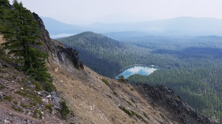
It seemed to take forever to get down to Indigo Lake, but I finally arrived on its muddy shores and admired the great view of Sawtooth's north flank. Indigo was a typical Oregon alpine lake; clean and clear and very shallow. There were a few campers at the lake, so I didn't stay long.
 |
| On The north shore of Indigo Lake looking up at Sawtooth Mountain |
From Indigo Lake it was just a nice walk in the woods for a couple of miles back down to the car. The whole hike was about 10 miles (my GPS said 11-ish but it lies) with almost 3,000 feet of climbing, and it took me a bit under 6 hours at a fairly leisurely pace and with my summit break. All-in-all a great hike and a wonderful day in the Cascades.
 |
| An easy stroll back down to the car |
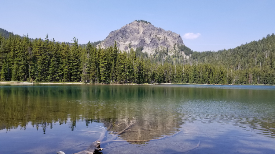
On the way out I was struck by the beautiful glassy surface of Timpanogas Lake which made it a perfect reflecting pool. I had to stop for a quick photo.
 |
| Timpanogas Lake reflection |
As I often do when I hike in the Diamond Peak area, I stopped at the creek-fed overhead hose which I think is used to fill water tenders in wilderness fire-fighting situations. You can climb up to the platform and turn the valve on, swivel the hose fitting out towards the road and drive back and forth through it as a means of getting most of the dirt road off of the car. It's a pretty decent car wash. I also soaked a towel and took a little towel bath so as not to stink up the car too much on the drive home.
 |
| Hillbilly car wash |
Sawtooth is well worth the trip and the effort. If you don't mind sharing the trail with dirt bikes and mountain bikes, this is a nice hike with a great scenic reward at the top.


