Lakeview Mountain
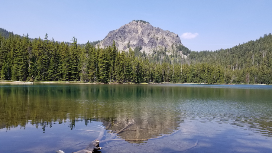
I saw an Instagram post one day of a small but very picturesque mountain. I had never seen or heard of Lakeview Mountain before, despite that fact that it's in the Cascades just about 60 miles from my home. It's also very near Crescent Lake, which I have visited many times, but it's not a large mountain and it's tucked away out of view, so I've never seen it.
This is a picture I snapped on my visit that is very similar to the Instagram post that first piqued my interest:
Consulting the maps, I saw that Lakeview would make a very good day hike, and I also thought I might be able to travel the ridgelines to visit the other three unnamed peaks to the south of Lakeview, so that was my tentative plan.

I set off early on Sunday, August 5th. Upon arriving at the trailhead area, I turned off at the dirt road just over the railroad tracks, but then I had some difficulty locating the trail (which is actually an old, disused snowmobile trail), but I found it about 100 yards south of where the tracks cross Crescent Lake Highway.

I think this is a lesser-used trailhead--I believe most people probably use the Fawn Lake Trail starting at its terminus at Crescent Lake Campground, close to the north shore of Crescent Lake.
I started up the trail with 5 liters of water and Gatorade as it was going to be quite a long hike and forecast to be a pretty warm day. The smoke from many southern Oregon forest fires hanging in the air would hinder my views for sure, but I didn't think it would be too bad.

When I reached the Fawn Lake Trail intersection, I stashed a liter of water behind a fallen tree for me to pick up on the return trip, lightening my pack a bit. Then I turned right and headed towards Fawn Lake.
About a mile in, a backpacking family of 5 passed me going the other way. They had probably camped at Fawn Lake and were heading home today. They would be the only people I would see all day.
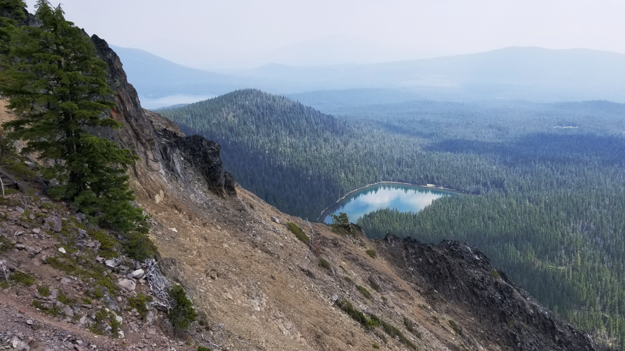
At about the three-mile mark I reached Fawn Lake, and it is a truly beautiful area. There are many campgrounds around the lake and it's a very appealing spot for a weekend getaway for anyone who doesn't want to have to hike in too far.

Here I turned right and joined the Stag Lake trail, enjoying the lakeside scenery as I went. At about 4.5 miles into the hike, I reached the end of the trail at the shore of the smaller but still beautiful Stag Lake. There is one campground on the east shore of Stag Lake where the trail ends, and it looks like a great place to spend a day or two.
From here I would say goodbye to trails for awhile. I wanted to bushwhack around to the west side of Stag Lake and then ascend the gully up to the saddle between Lakeview and its neighbor to the south. This was roughly the plan:

At this point I should mention that I stupidly forgot my handheld GPS unit at home, and was relying on my paper maps. I should have fished my compass out of my pack and taken a bearing on the saddle while I could see it from Stag Lake, but I trusted that I would be able to more-or-less just go uphill and gain the ridgeline at the saddle between Lakeview and the other peaks. That was dumb. Once I got into the woods, all visual references were lost and I was seduced by a good line up a ridge, and I ended up going too far south. Even though my bearing error was only 10 or 20 degrees to the left of where I should have gone, it was bad enough that I soon found myself on the extremely steep slopes of the unnamed easternmost peak, cursing to myself and trying to make my way over to friendlier terrain. After some very difficult and treacherous side-hilling to get myself going in a more northerly track, I was finally able to gain the ridgeline in the wrong saddle. This is what the actual route looked like:

Okay, I guess I would be visiting the middle peak of the southern three peaks first.
The ridgeline travel was much more rugged and difficult than I expected, and it was laborious and slow going. I reached the middle peak, then turned north towards Lakeview. It was another difficult ridgeline followed by the loose rocky scramble up to the top of Lakeview. The views from the summit were smoky, but still wonderful.


At this point it looked like there might be some thunderstorm activity starting to form so I descended from the summit and had lunch back down in the saddle on the ridgeline. I was already pretty tired and still had a long way to go.
Heading back towards the line of three unnamed peaks, I decided I'd had just about enough of this ridgeline travel, and I now focused only on getting to the saddle between the middle and western peaks, and then descending south from there to get back on the trail and return towards Fawn Lake. I skirted around the middle peak, thinking that following the contour around the west side would be easier than climbing to the top and then back down to traverse that peak. I'm not sure my contouring plan was any easier--it was very steep and rough terrain, so even that little quarter-mile was tough.
Continuing southwest along the ridge, I went down far enough until the terrain looked friendly enough, then I turned left and headed down. After 15 or 20 minutes of not-too-difficult bushwhacking, I was back on the trail not far from from Saddle Lake.

Now I was just going to stick to the trails and loop around on the Pretty Lake Trail instead of taking the Fawn Lake Trail back towards the car. Backtracking on Fawn Lake Trail would be significantly shorter, but I wanted to take the opportunity to see everything while I was out here.
The rest of the hike was quiet and uneventful. The thunderstorms I thought might be forming never materialized. As I passed by Redtop Mountain, I noted that its north ridge looked very climb-unfriendly. I probably won't seek out that summit anytime soon.
I didn't care much for the Pretty Lake Trail. It's been heavily used by equestrians, and horses are very hard on trails. They pulverize the dirt into a fine, dusty sand that gets into your boots, socks, eyes and lungs, and they turn a flat trail into a large U-shaped trough. Walking in this indentation is very hard on the feet and ankles. And you're choking on the sandy dust and dodging horse manure piles. I always try to avoid horse trails whenever I can, but on this day I spent a lot of time on them.
I slogged down the trail back to my turnoff, picked up my water bottle from behind the tree and continued toward the car. I only drank about 3.5 liters of liquid on the whole hike, so the 5 liters was overkill, but it's better to have too much than too little I guess. Filtering/purifying water at Fawn, Stag, Saddle or Pretty lake would have been a good option as well.
Here's the crummy GPS track from my Garmin Fenix 5 watch:

And here's the little overview video of the trip from the Relive & Strava apps, using GPS data from my watch (note that Relive often puts some of the photos in the wrong spots):
My Garmin watch says the trip was 16.1 miles, so in reality it was probably more like 15-ish miles. All in all a pretty good workout and a nice day out in the woods. I highly recommend Lakeview, but you can skip the other peaks. They're really not worth the trouble.


0 comments:
Post a Comment