Ted is a husband, father, hiker, climber, backpacker, Oregonian, Air Force veteran, pilot, cat herder, new grandfather, recovering coder, and SQL Server DBA. Ted works hard on trying to be a decent human, not getting too fat, and just generally trying to keep life fun and interesting for himself and his family.

Showing posts with label Climbing. Show all posts

Sunday, October 21, 2018

Sawtooth Mountain


I've been wanting to get out to Sawtooth Mountain for a long time.  It's a great little mountain, but tends to slip down the priority list in the summer when there are grander peaks to climb.  With this year's very mild fall (so far), I had a good opportunity this month to go and cross this one off my to-do list.

I initially tried to go on Sunday the 14th.  The forecast was for a bit of wind--20 MPH at the summit--but it didn't look too bad.  But as soon as I got past Hills Creek Lake and was headed east on Forest Service Road 21 (Rigdon Road), I was surprised at the increasing and sustained ferocity of the wind.  The road was covered in small branches and pine cones and the gusts were quite remarkable.  I initially thought about canceling, but I remained optimistic and pressed on.  Then I had to stop to clear a downed tree off the road.  Fortunately the tree broke into manageable pieces when it fell, so I was able to clear a gap wide enough to get my car through.

Tree down!

About two miles before I reached the trailhead at Timpanogas Lake, I decided this whole endeavor was probably unwise.  It was 31 degrees and the wind was howling at about 30 MPH with stronger gusts.  There was a very good chance that a tree would come down and block my exit back to Highway 58 and in this area there's no cell signal to call for assistance.  And I knew if I went out to hike in this that it would be a bitterly cold and miserable experience, so I cursed the bad forecast and turned around to head home.

I went back a week later on the 21st, and I couldn't ask for a better day.  It was cool and still and sunny--a perfect Oregon fall day.

Coming in to Timpanogas Lake from Rigdon Road, you have to endure 7 or 8 miles on a wide, gravely dirt road (Road 2154) that is heavily washboarded on every incline and curve.  It'll really rattle the fillings out of your teeth.

I made a pit stop at the Timpanogas campground, which is really just about 100 yards from the trailhead. Just so you know, the Sawtooth Mountain/Indigo Lake trailhead has the benefit of a toilet at the Timpanogas campgrounds, so it's always nice to be able to comfortably take care of business before hiking, if you know what I'm saying.

I had a leisurely start from the house, and after the 90-mile drive I finally hit the trail at around 10:30.  I took the southwest trail instead of the more direct Indigo Lake trail so I could see more of the area.  It was fairly steep and heavily wooded, so although the woods were very pretty, there wasn't much to see.

I was dismayed to see that pretty much everything was allowed on this trail system.  People, horses, bikes, and even motorcycles.  Now I know dirt-biking is a heck of a lot of fun, but I wish pristine wilderness areas such as this could be free of motorized vehicles.  Plus I think that motorcycles on a trail that's heavily used by hikers is just a bad idea.  And motorcycles and horses on a rugged, narrow trail?  That's definitely a bad combo.  At any rate, I was enjoying the hike and I didn't expect to really see any dirt bikers out here.

A bit after taking a left at the June Lake trail junction, I got to the Indigo Lake trail three-way junction about a mile into the hike.  I took the middle fork--the Sawtooth Mountain trail.  You can also get to the summit via the Indigo Lake trail but I was going for a counter-clockwise loop just because it looked like the best way to go on paper.  You get most of the climbing out of the way before the summit trail so it's not a long climb to the summit like it would be from the Indigo Lake trail.

After another mile I was crossing the high ridge running down from southeast to northwest, and the trail got very rugged and quite steep in spots.  Certainly not something I'd want to try on either a mountain bike or a motorcycle.  It looked like a trail that didn't get much use, and sure enough I didn't see anyone on it all the way up to Sawtooth.  I had the forest all to myself.

Gaining the saddle about a mile to the west of the Sawtooth summit, the trail turned east to approach Sawtooth's south side.  The hiking here was scenic, easy and pleasant, but there were not yet any views of Sawtooth so it was difficult to gauge just where I should be looking for the turnoff to head up to the summit.

Route overview

Just about when I thought I'd gone too far east and passed it, I came across the unmarked summit trail and from there it was a relatively short hike with a bit of scrambling around gendarmes and up some rocks to get to the summit.  Partway there I came around a rock formation and an older gentleman, the first person I'd seen all day, was sitting nearby eating some lunch.  He and I both jumped a bit.  He exclaimed, "You scared the shit out of me!", to which I replied, "Well you scared the shit out of me, too!".  We both had a little chuckle.  He was heading down so after a brief chat we went our separate ways.

Up on the summit I took off my pack for a rest and got a snack to refuel.  With fires still burning in southern Oregon, the view to the south and east was quite hazy from the smoke, but looking northwest, it was beautiful!  Beyond Sawtooth's large talus field, Indigo, Timpanogas, and Summit Lakes, and Diamond Peak all lined up perfectly for an amazing view.  To the northeast, Cowhorn Mountain was a prominent sight; Nora and I climbed that one back in July and it was a great hike and a fun rocky scramble to the top.

As I rested and ate, two hikers came up and went to a rocky prominence at the northern part of the summit, leaving me alone on the small, flat summit.  I was curious about these two.  They looked to be in their 20's, and were wearing clean clothes and not carrying packs or water bottles.  I wondered were they came from?  Even if they came up from an Indigo Lake camp they'd at least need some water.  Strange.

Please forgive the vertical orientation of some of these pics/vids. They were shot for apps that don't do well with landscape pics/vids.


Looking up at the summit

The sentinel in the south scree field (There's a little tree growing out of the top of it)

Indigo Lake, Timpanogas Lake, Summit Lake and Diamond Peak
as viewed from near the summit of Sawtooth

Obligatory summit selfie (squinting into the very bright sun)

Sawtooth on the left; Cowhorn Mountain in the distance on the right

I started down, scrambling over and around the rocks and descending back to the trail where I turned northeasterly to continue my loop.  The trail descended very steeply through a wide drainage filled with trees with remarkably curved trunks as the trail meandered toward the saddle on the east side of Sawtooth.  The total descent was almost 1,000 feet making me glad I decided to do the loop in a counter-clockwise direction because it looked tough going the other way. 

Descending the steep drainage

Bendy trees 1

Bendy trees 2

In this section I was surprised by two motorcyclists heading my direction on the trail, coming up from behind me.  Well I guess I was going to see some dirt bikers today... 

After nearly a 300-foot climb up to the saddle, it was all downhill from there, down the Indigo Lake trail and back to the trailhead at Timpanogas Lake.  

On the way down to Indigo Lake, I heard the motorcyclists now coming up this trail, gingerly picking their way through the difficult parts with noisy bursts of throttle, and they went by me once again.  Motorcycle noise and smelly exhaust in the wilderness.  Lovely.  It occurred to me at this point that the two guys I saw on the summit without any gear were probably the riders who left their bikes and gear tucked away near the Sawtooth summit trail junction.  That would explain their cleanliness and lack of hiking gear.

It seemed to take forever to get down to Indigo Lake, but I finally arrived on its muddy shores and admired the great view of Sawtooth's north flank.  Indigo was a typical Oregon alpine lake; clean and clear and very shallow.  There were a few campers at the lake, so I didn't stay long.

On The north shore of Indigo Lake looking up at Sawtooth Mountain

From Indigo Lake it was just a nice walk in the woods for a couple of miles back down to the car.  The whole hike was about 10 miles (my GPS said 11-ish but it lies) with almost 3,000 feet of climbing, and it took me a bit under 6 hours at a fairly leisurely pace and with my summit break.  All-in-all a great hike and a wonderful day in the Cascades.

An easy stroll back down to the car

On the way out I was struck by the beautiful glassy surface of Timpanogas Lake which made it a perfect reflecting pool. I had to stop for a quick photo.

Timpanogas Lake reflection

As I often do when I hike in the Diamond Peak area, I stopped at the creek-fed overhead hose which I think is used to fill water tenders in wilderness fire-fighting situations. You can climb up to the platform and turn the valve on, swivel the hose fitting out towards the road and drive back and forth through it as a means of getting most of the dirt road off of the car. It's a pretty decent car wash. I also soaked a towel and took a little towel bath so as not to stink up the car too much on the drive home.

Hillbilly car wash

Sawtooth is well worth the trip and the effort. If you don't mind sharing the trail with dirt bikes and mountain bikes, this is a nice hike with a great scenic reward at the top.

Wednesday, September 19, 2018

Boundary Peak, Nevada


tldr; the video trip report is on YouTube here.

The way my vacation meanderings worked out, Boundary Peak would be my last hike/climb of the somewhat epic, seven-state, 2018 End-of-Summer road trip; aka, Ted's Excellent Adventure. I was disappointed that I never got good enough weather to try Borah Peak in Idaho or Kings Peak in Utah, but all things considered, everything worked out pretty well and I got to see and do a lot of things that I wanted to see and do.

I left Bishop, California, very early in the morning, trying not to wake up others in the little motel I was staying in. I grabbed some coffee from the Starbucks in town and avoided the temptation to get a donut from the donut shop next door, and I ate a protein bar instead as I headed north on Highway 6 towards the Dirt Road From Hell™ that would take me to Boundary Peak trailhead.

Two miles into Nevada I turned south onto the unmarked dirt/gravel trailhead approach road, just as I had done 9 days earlier when a sharp rock and a flat tire thwarted my plans to climb the mountain. This time I drove very slowly and carefully, but it's not like you can avoid hazards on this road. It took me over 30 minutes to make my way 6 miles up the road towards the trailhead. This is the worst road I have ever attempted to drive on. I've read a lot of Boundary Peak trip reports that briefly mention the poor state of this road, but let me make it clear. Your rental Prius/Corolla/Charger/Mustang/minivan/whatever isn't going to make it up this road. You need pretty much a real Jeep or a dirt bike if you expect to make it all the way to the trailhead.

I have a Nissan Murano that has relatively good ground clearance for the small-SUV type of vehicle it is, but I was tense all the way on this road. It is full of sharp rocks, ruts, washouts and high spots that are just trying to rip up a tire or take off your oil pan. This road is no joke. Dash cam video doesn't do it justice at all, but here's some from my dash cam.

I got to a point right at Queen Mine where I could see the final bit of road leading up to the trailhead, and that was as close as I felt I could get without risk of damage to my car. This would have to do as my starting point, so I parked and got my gear ready, threw my pack on and started up the road to the trailhead on foot.

Even though it is a sought-after state high point, Boundary Peak is a little obscure and out-of-the-way, so I know it's not a high-traffic mountain. I truly expected to be the only climber on the mountain on a Wednesday in mid-September, so I was surprised first when I saw an empty Volkswagen SUV parked a little higher up along the road, and then again when I saw a white Jeep slowly crawling its way up the road far below me as I hiked up towards the trailhead. I guess I would have company today.

The white Jeep caught up to me when I was about a half-mile up from my car. They stopped and the two guys inside offered me a ride. It looked like it would be inconvenient for them to rearrange the back to make room for me and my pack, so I politely declined and just let them go on. Unfortunately for me, my inconvenient parking spot added a mile each way on my hike, plus over 800 vertical feet just to get up to the trailhead. It was making an already difficult day much harder.

Some extra work just to get to the trailhead
I caught up to the guys in the Jeep at the trailhead, and we talked about the various mountains we have climbed for a good 20 minutes or so. Nice guys; looked to be in their 20's and fit, so I knew they'd be fast and I wouldn't see them the rest of the day. As they departed up the trail, another group of six guys came up from the east side of the trailhead. They'd come in the other way in a rental minivan that didn't get anywhere near the trailhead. They had hiked up 3 or 4 miles just to get to the trailhead. But they too were young guys and strong climbers; they could handle it.

We all started up the mountain right at about 8 AM, and they all soon outpaced me, so I was well behind them and hiking alone within an hour. I also stopped fairly often to take pictures and shoot video, and try a new thing where I sort of narrate what's going on with the climb. I'll see if I can string those video segments together for some sort of useful video trip report to post on YouTube.

After a moderate 1,000 foot ascent, the trail more-of-less levels out for nearly 2 miles as you approach Trail Canyon Saddle at the base of the imposing-looking Hosebag Peak. You have to climb Hosebag to get to Boundary Peak's north ridge, which leads up to the summit.

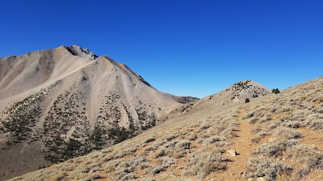
Looking south from the ridge trail towards Trail Canyon Saddle, Hosebag Peak and Boundary Peak

The hike to Trail Canyon Saddle was uneventful, and Hosebag Peak loomed large. It looked very difficult. The trail up Hosebag gains over 1,100 feet in a bit over a half-mile, so it's quite steep and a very physically demanding section of trail. There was also a very strong, cold wind blowing consistently in this area, and I was concerned for awhile about being mildly hypothermic. It was very tiring. Partway up Hosebag I met the Volkswagen SUV owners on their way down. They were early starters and fast movers for sure. We chatted for a bit--they were nice folks.

The trail ceases to be a trail about a third of the way up Hosebag Peak. As with most climbers' trails, tracks just spider web all over the place and you just have to try to pick the line of least resistance for yourself as you ascend or descend. And it's 90% boulder hopping anyway, trying to find good rocks that don't move under your feet. These mountains are really just big piles of rocks held together with a little bit of dirt.

After getting past Hosebag and part way up Boundary's north ridge, I became aware of a very deep and ominous-sounding rumble from some distance away. I stopped to look around, puzzled as to what was happening. My first thought was that I was hearing an earthquake because it sounded like a very loud and not-too-distant earthquake. This worried me because if this mountain started shaking, big boulders were going to start falling, probably including the ones I was standing on, and it could get ugly fast, for me and the other 10 people on the mountain. But as I heard more rumbling and didn't feel any movement, I figured it had to be something else. I now could see a very large plume of dirt or smoke or ash in the distance to the west, probably 30 to 40 miles away. As I took some video of that, I now (wrongly) surmised that Mammoth Mountain, a very seismically-active volcano, had had a volcanic 'burp'. That's what the plume looked like; a small volcanic ash cloud. Thankful that the mountain I was on wasn't doing anything, I watched the plume until all the rumbling noises stopped before continuing up the mountain.

I now think that this was probably some very large-scale blasting for some sort of highway or mining project. I can't think of anything else it could have been.

Anyway, now above 12,200 feet, the climb was just a matter of stubbornness; a climber's most valuable commodity. Climb 20 or 30 steps, stop, rest, pant for air, repeat. Eventually you make it to the top, which I did at around 1:30 PM.

I took some pictures and video, ate a small snack and signed the summit register found in a large ammo can. It was a clear and cloudless day with zero wind on top, and the views were spectacular in every direction. I didn't think a desert mountain would be much to look at, but Boundary Peak is a very good-looking mountain.

On the summit

Just over a half-mile to the southwest was Montgomery Peak, sticking up a couple hundred feet higher than Boundary Peak. Montgomery is over the state line in California, though, so Boundary is king in Nevada. In planning this hike I thought I'd also like to also get over to Montgomery while on this climb, but the connecting saddle is seven tenths of a mile of very rugged terrain with an additional climb of several hundred feet, and that would add an hour or more to the trip, so I decided that I would not make the attempt.

At around 2 PM I closed up my pack and the summit register box (an ammo can) and started down. All others were well below me now and I was for all intents and purposes alone on the mountain for the rest of the day. I don't mind this. Solitude on a big mountain is a special thing which I covet as a rare treat.

The trip down the north ridge and Hosebag's steeply-descending boulder field was slow and arduous, as expected. Then when I reached the more-or-less flat 2-mile section, it seemed to go on forever. Every time I thought I was near the end, another section of trail appeared over the crest and it just went on and on.

I finally got to the last 1,000-foot descent to the trailhead where I signed out of the log and sat on a rock to rest for a few minutes. Then I started down the last mile on the rocky road to my car at Queen Mine. It was a very quiet and lonely mountain with everyone long gone by now. Approaching early evening, the shadows grew long and I kept my head on a swivel for cougars (not the good kind). There's been too much news of cougar attacks lately which makes your mind go to dark places when you're alone in the wilderness.

I had myself a nice wet-wipe bath at the car and put on some clean clothes as it would be hours before I reached any place with a motel, and then it took me a good 30 minutes to get my car down the mountain safely before I jumped on Highway 6 westbound and headed for Highway 395 in California. I had a new granddaughter, my first grand-baby, to go visit tomorrow.

Boundary Peak is a great climb and a fantastic mountain. It's a very challenging hike and the mountain is probably more scenic than what you'd expect in the Nevada desert, and the summit views are incredible. Highly recommended (but only if you have a very good, high clearance 4WD vehicle to get there!).

The elevation profile from my GPS watch (not the most accurate thing in the world)

Click here for an interactive topo map on caltopo.com with my GPS track overlay.

There are not a lot of photos in this post as I mostly took video during this one. If you'd like to see that edited video trip report, it's here on YouTube.

Thanks for reading!

Ted

Sunday, September 16, 2018

Wheeler Peak in New Mexico


After finishing the Mt Elbert hike in Colorado, I immediately drove five hours south to Taos, New Mexico. I spent a couple of days there relaxing and roaming about the town. It's a pretty nice place.


Taos and north central New Mexico

On Sunday the 16th I left town very early and headed up to Taos Ski Valley, to the Williams Lake trailhead, which is a large dirt parking lot. There were only a handful of cars there when I arrived, and I got my gear together, put on my pack and headed up the trail just a bit after sunrise.

The first half mile or so winds through the ski resort, and then you're into the woods. A pair of fast hikers overtook me not long after I started, and then I had the trail to myself. It was cool and quiet, and much more wooded than I expected.

The trail to Williams Lake is relatively gentle and gains a little over a thousand feet in about 1.9 miles. At the lip around the lake, before you actually see the lake, the Wheeler Summit trail branches off to the left (east) and starts switchbacking up Wheeler's steep western slope.

Soon after I started up, a solo hiker came up behind me and passed me by without exchanging any pleasantries. He was a man on a mission, I suppose.

The topo maps look like this section will be a strenuous climb, but it's really not bad at all. It averages about a 16% grade and the switchbacks are well designed to make the route manageable for most hikers. There a few talus fields along the way to cross where careful foot placement is required, but they're not too bad.

The Williams Lake Trail Route

Just above treeline, looking up at Wheeler Peak

Before I knew it, just a little over two-and-a-half hours into the hike, I was at the saddle just to the north of Wheeler Peak, in between Mount Walter and Wheeler Peak. The rest of the ridge traverse to the Wheeler summit only takes a few minutes, and although it was a bit cold and breezy there in the saddle, the view was absolutely beautiful in every direction.


The fast solo hiker that passed me earlier on the ascent had tagged the summit and now descended past me just as I reached the saddle, again without a word. As I crossed the ridge to the summit, the couple that I had seen near the parking lot started their descent from the summit, leaving me alone on the ridge and at the summit. There are few things better than some time alone on a summit. I enjoyed a snack and some Gatorade, and took some pictures.

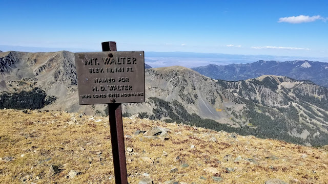
After about 10 minutes I heard a couple coming up, and after another few minutes or so they were nearing the summit. I greeted them as they came up, and we chatted for a bit. They were locals and the woman mentioned that Mt Walter, just to the north of the saddle where we came up, is the second highest mountain in New Mexico, so I thought, "Well, hell, I guess I need to go over there and tag that one, too!"


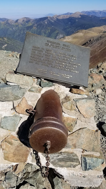
Strange summit plaque

Northern view from Wheeler summit

Summit Benchmark

Southeast view from the Wheeler summit, looking at Old Mike Peak (right)


I snapped a summit picture for the couple, and then left them on the summit of Wheeler and I crossed the ridge and climbed the other side of the saddle to briefly visit Mt Walter, which is just 28 feet shorter than Wheeler. So it was kind of a twofer hike for me.

Looking west from Mount Walter

Looking over at Wheeler from Walter

I then returned to the saddle and started down the switchbacks.


About halfway down offered the only view of Williams Lake, which is the destination of many hikers on the Williams Lake trail.

Williams Lake at the valley floor

I passed a gazillion hikers who were on their way up as I descended. This is a popular trail, especially on a weekend, and I was very glad that I'd started early and beat the crowd. It was quite the conga line of people going up; over a hundred people would be my estimate. And down in the valley, many of the hikers along the Williams Lake portion of trail were casual hikers; people out for some Sunday time in the woods, and unfortunately, many were unaware of or unconcerned with leave-no-trace principles or any trail etiquette. Many children were freely roaming in off-trail areas, apparently on destroy-all-nature missions while oblivious parents strolled along. One unleashed dog seemed quite intent on ripping my leg off, and as I yelled at the dog and prepared to spear him in the head with my hiking pole as an act of self defense, I gave his owner an angry, WTF kind of look and said, "Don't you think that a maybe a leash would be an appropriate thing for this dog??? There's tons of little kids running around out here." He said something like, "Yeah, I guess I should do that." People can be incredibly thoughtless sometimes. And when I say thoughtless, I really mean moronic.

There was dense trail traffic for the entire 4 miles back to the car, and the parking lot was overflowing with cars when I got there. The descent only took me about 90 minutes, so the whole hike including time on the summit was about 5 hours; significantly faster than I expected.

I left the parking lot immediately to free up a spot for others, and I cleaned up and changed clothes at a quiet spot further down the mountain before I headed into town for lunch, and then onward to my next destination.

It looked like the only state high point that I could get to that had a decent weather forecast was good old Boundary Peak in Nevada, so I was headed west to try that one again. This time I hoped to make it all the way up to the trailhead without puncturing a tire so I could do the hike.

Anyway, Wheeler is scenic and pretty easy, and I recommend this hike as a great climb. But go on a weekday if you can, and go early!

P.S., This trail is full of rugged sections with very sharp rocks, and I'm really tired of seeing limping dogs in obvious pain on climbs like this with selfish owners urging them on. Although this trail is relatively short and easy, it's really not a good trail for dogs; please don't abuse your dogs like this--leave them at home.

Sunday, August 5, 2018

Lakeview Mountain


I saw an Instagram post one day of a small but very picturesque mountain. I had never seen or heard of Lakeview Mountain before, despite that fact that it's in the Cascades just about 60 miles from my home. It's also very near Crescent Lake, which I have visited many times, but it's not a large mountain and it's tucked away out of view, so I've never seen it.

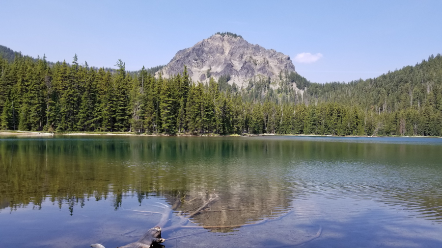
This is a picture I snapped on my visit that is very similar to the Instagram post that first piqued my interest:

Looking at the east face of Lakeview Mountain from Stag Lake


Consulting the maps, I saw that Lakeview would make a very good day hike, and I also thought I might be able to travel the ridgelines to visit the other three unnamed peaks to the south of Lakeview, so that was my tentative plan.

Lakeview Mountain and the Crescent Lake area


I set off early on Sunday, August 5th.  Upon arriving at the trailhead area, I turned off at the dirt road just over the railroad tracks, but then I had some difficulty locating the trail (which is actually an old, disused snowmobile trail), but I found it about 100 yards south of where the tracks cross Crescent Lake Highway.

Trailhead area just off of Crescent Lake Highway


I think this is a lesser-used trailhead--I believe most people probably use the Fawn Lake Trail starting at its terminus at Crescent Lake Campground, close to the north shore of Crescent Lake.

I started up the trail with 5 liters of water and Gatorade as it was going to be quite a long hike and forecast to be a pretty warm day.  The smoke from many southern Oregon forest fires hanging in the air would hinder my views for sure, but I didn't think it would be too bad.

Trails overview. Fawn Lake Trail, Stag Lake Trail and Pretty Lake Trail.


When I reached the Fawn Lake Trail intersection, I stashed a liter of water behind a fallen tree for me to pick up on the return trip, lightening my pack a bit.  Then I turned right and headed towards Fawn Lake.

About a mile in, a backpacking family of 5 passed me going the other way.  They had probably camped at Fawn Lake and were heading home today.  They would be the only people I would see all day.

At about the three-mile mark I reached Fawn Lake, and it is a truly beautiful area.  There are many campgrounds around the lake and it's a very appealing spot for a weekend getaway for anyone who doesn't want to have to hike in too far.

Lakeview Mountain (right) and unnamed peak (center) from Fawn Lake


Here I turned right and joined the Stag Lake trail, enjoying the lakeside scenery as I went.  At about 4.5 miles into the hike, I reached the end of the trail at the shore of the smaller but still beautiful Stag Lake.  There is one campground on the east shore of Stag Lake where the trail ends, and it looks like a great place to spend a day or two.

From here I would say goodbye to trails for awhile.  I wanted to bushwhack around to the west side of Stag Lake and then ascend the gully up to the saddle between Lakeview and its neighbor to the south.  This was roughly the plan:

The plan to reach the saddle

At this point I should mention that I stupidly forgot my handheld GPS unit at home, and was relying on my paper maps.  I should have fished my compass out of my pack and taken a bearing on the saddle while I could see it from Stag Lake, but I trusted that I would be able to more-or-less just go uphill and gain the ridgeline at the saddle between Lakeview and the other peaks.  That was dumb.  Once I got into the woods, all visual references were lost and I was seduced by a good line up a ridge, and I ended up going too far south.  Even though my bearing error was only 10 or 20 degrees to the left of where I should have gone, it was bad enough that I soon found myself on the extremely steep slopes of the unnamed easternmost peak, cursing to myself and trying to make my way over to friendlier terrain.  After some very difficult and treacherous side-hilling to get myself going in a more northerly track, I was finally able to gain the ridgeline in the wrong saddle.  This is what the actual route looked like:

The reality of poor navigation


Okay, I guess I would be visiting the middle peak of the southern three peaks first.

The ridgeline travel was much more rugged and difficult than I expected, and it was laborious and slow going.  I reached the middle peak, then turned north towards Lakeview.  It was another difficult ridgeline followed by the loose rocky scramble up to the top of Lakeview.  The views from the summit were smoky, but still wonderful.

Looking at Lakeview Mountain's south ridge from the saddle

About halfway up Lakeview

Looking back down at the ridgeline from Lakeview's south ridge

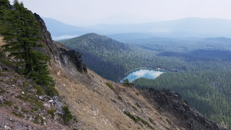
Smoky skies and Stag Lake from near Lakeview's summit

The west flank of Diamond Peak in the smoky distance

Obligatory Summit Selfie

Difficult traveling along the rugged ridgelines

At this point it looked like there might be some thunderstorm activity starting to form so I descended from the summit and had lunch back down in the saddle on the ridgeline.  I was already pretty tired and still had a long way to go.

Heading back towards the line of three unnamed peaks, I decided I'd had just about enough of this ridgeline travel, and I now focused only on getting to the saddle between the middle and western peaks, and then descending south from there to get back on the trail and return towards Fawn Lake.  I skirted around the middle peak, thinking that following the contour around the west side would be easier than climbing to the top and then back down to traverse that peak.  I'm not sure my contouring plan was any easier--it was very steep and rough terrain, so even that little quarter-mile was tough.

Continuing southwest along the ridge, I went down far enough until the terrain looked friendly enough, then I turned left and headed down.  After 15 or 20 minutes of not-too-difficult bushwhacking, I was back on the trail not far from from Saddle Lake.

Down from Lakeview Mountain, around the middle peak and descent back down to the trail

Now I was just going to stick to the trails and loop around on the Pretty Lake Trail instead of taking the Fawn Lake Trail back towards the car.  Backtracking on Fawn Lake Trail would be significantly shorter, but I wanted to take the opportunity to see everything while I was out here.

The rest of the hike was quiet and uneventful.  The thunderstorms I thought might be forming never materialized.  As I passed by Redtop Mountain, I noted that its north ridge looked very climb-unfriendly.  I probably won't seek out that summit anytime soon.

I didn't care much for the Pretty Lake Trail.  It's been heavily used by equestrians, and horses are very hard on trails.  They pulverize the dirt into a fine, dusty sand that gets into your boots, socks, eyes and lungs, and they turn a flat trail into a large U-shaped trough.  Walking in this indentation is very hard on the feet and ankles.  And you're choking on the sandy dust and dodging horse manure piles.  I always try to avoid horse trails whenever I can, but on this day I spent a lot of time on them.

I slogged down the trail back to my turnoff, picked up my water bottle from behind the tree and continued toward the car.  I only drank about 3.5 liters of liquid on the whole hike, so the 5 liters was overkill, but it's better to have too much than too little I guess.  Filtering/purifying water at Fawn, Stag, Saddle or Pretty lake would have been a good option as well.

Here's the crummy GPS track from my Garmin Fenix 5 watch:

Complete route.  Both loops were counter-clockwise.


And here's the little overview video of the trip from the Relive & Strava apps, using GPS data from my watch (note that Relive often puts some of the photos in the wrong spots):


My Garmin watch says the trip was 16.1 miles, so in reality it was probably more like 15-ish miles.  All in all a pretty good workout and a nice day out in the woods.  I highly recommend Lakeview, but you can skip the other peaks.  They're really not worth the trouble.